Chiricahua National Monument
southeastern Arizona
Visited: March 9, 2005
NPS Site Visited: 168 of 353
NPS Website
 WHAT IS IT? WHAT IS IT?
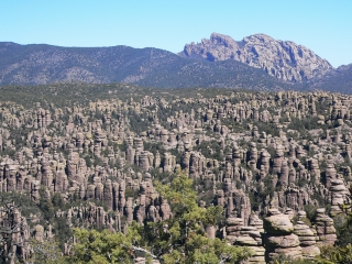
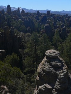
An unexpectedly soaring high altitude “sky island” oasis, the remnants of a 27 million-year old violent volcanic eruption. The result is towering narrow hoodoo rock pinnacles surrounded by mountains in a land that holds an incredible variant of animal and plant species.
BEAUTY (9/10)
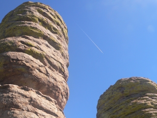
How did we not know about Chiricahua, a place of unique and awe-inspiring beauty? The Park’s remarkable fields of rhyolite hoodoos are very similar to the iconic reddish orange rock towers of Bryce Canyon NP in Utah. Chiricahua’s hoodoos are grey and composed of a different rock; rhyolite is volcanic ash particles, superheated and fused together.
Multi-colored lichen, infinite shades of yellow, green and orange cover Chiricahua’s hoodoos. What do they look like? How active is your imagination?
Chiricahua NM is also located at an ecological crossroads, holding migrating Rocky Mountain species from the north, Chihuahuan Desert species from the east, Sierra Madrean species from the south and Sonoran Desert species from the west. The rock pillars are not the only show.
HISTORIC SIGNIFICANCE (4/10)
The Chiricahua Apaches lived in and around the area. They believed the “standing up rocks” to be a sacred place. We agree with this assessment; Chiricahua feels like a special place.
The large mountain to the northeast of the park is called Cochise Head; it does resemble the profile of a man lying done. The elusive Cochise never allowed himself to be photographed or painted; the rock is his only earthly representation.
 CROWDS (8/10) CROWDS (8/10)
Chiricahua NM does not get the same amount of publicity as the red hoodoos down the road. The location is remote. Rock climbing and bouldering are prohibited which might thin the crowds as well. The roar of RV generators is not omnipresent; there are not throngs of people on the trails.
There were, however, enough to fill the small campground. All of our camping neighbors were friendly and polite, as were the three older couples who took the hikers shuttle with us in the morning.
We encountered the same couple a few times on the trail, sometimes birding, sometimes resting. They are the ones who suggested Madera Canyon, world class birding area, as a future stop. (Without their recommendation, we may have missed seeing two migrating species of hummingbirds whose narrow route takes them through the Canyon.)
One would expect a location as beautiful as Chiricahua NM to be overrun with hikers, photographers, outdoor enthusiasts. Instead we felt as if we had stumbled across a forgotten treasure.
EASE OF USE/ACCESS (2/5)
The down side is that Chiricahua NM is about 120 miles from the nearest city, Tucson, Arizona; it is about 45 miles from the Willcox exits of Interstate 10.The plus side is that the road through the park is entirely paved and that it takes you to many picturesque overlooks if you are not the hiking type.
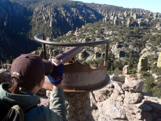
If you wish to hike into the hoodoos, a 3.5-mile loop travels around Echo Canyon. Do not miss the wonderful 7-mile hike that travels from Massai Point down to the Visitor Center. This trail passes through the most spectacular and famous of the Park’s rock formations. The hike is mostly downhill.
The Park Service offers a free shuttle at 8:30 a.m. from the Visitor Center to Massai Point that allows you to enjoy the hike with your car waiting for you at the bottom.
CONCESSIONS/BOOKSTORE (4/5)
Books on Apache history and culture, biographies of Geronimo, Cochise and various cowboys of the Wild West and a dozen titles from the children’s Mysteries in Our National Parks series are available here. The National Park chocolate animal crackers that we bought while waiting for the shuttle were much tastier than expected.
 COSTS (3/5) COSTS (3/5)
Entry is $5 per person, free with the National Parks Pass. The lovely Bonita Canyon campground has 22 spots available on a first-come, first-served basis. Sites are an affordable $12. There are few other overnight options nearby. Backcountry camping is not allowed. Plan accordingly, campground sites can fill up in the early spring high season.
RANGER/GUIDE TO TOURIST RATIO (5/5)
The Student Conservation Association is active at Chiricahua NM. We saw at least 3 different SCA volunteers. But they complimented rather than took the place of Rangers, who were also present at the Visitor Center each time we stopped by. With the exception of a surly campground host, Chiricahua NM appears to be run by an all female staff.
TOURS/CLASSES (4/10)
The Site’s aging museum is dedicated to the Civilian Conservation Corps which improved the Monuments roads and blazed the trails that are still in use today. The museum displays personal effects of CCC members and an overview of Franklin D. Roosevelt’s Tree Army next to photographs of the workers and inhabitants of this ecological four corners.
Chiricahua NM distributes a free newspaper which details each of the Site’s trails, their difficulty and accessibility. Its articles are fun as well as informative and supplement the VC’s older displays.
There is a short self-starting video narrated by hometown legend Rex Allen, Sr. in a warm corner of the museum. The couches are comfy – a little too comfy. We nearly dozed back to sleep as the Singing Cowboy's warm voice told us about the natural beauty and wildlife inhabitants of Chiricahua in every season and altitude.
There are no Ranger-led walks into the rocks but there are guided tours of Faraway Ranch and Stafford Cabin, former homestead of Swedish immigrants whose daughter and husband were the first to promote the “Wonderland of Rocks.”
 FUN (8/10) FUN (8/10)
Some of the “standing up rocks” have names. Most don’t, leaving room for comments like this one: “Look! It’s a sick alligator wrapped in a blanket with a hot water bottle on his head!” Laugh, but look closely at the photo and tell us if you don’t see a resemblance.
WOULD WE RECOMMEND? (8/10)
Chiricahua NM is a hidden gem. When we left Fort Bowie NM and drove into Chiricahua NM, all we were hoping for was a place to pitch our tent. What we found was a sky island filled with intriguing shapes, peaceful trails, friendly Rangers, and a campground so clean and comfortable we were contemplating another night’s stay, even though temperatures dropped to the 30s at night.
The plusses of Chiricahua NM outweigh its remote location: There is an NPS historical site less than an hour away. Four ecosystems converge inside the Monument’s boundaries. Did we mention the FREE shuttle to the trailhead at Massai Point?
TOTAL 55/80
|