Capitol Reef National Park
Torrey, Utah
Visited: April 20, 2005
NPS Site Visited: 193 of 353
NPS Website; Local Website
WHAT IS IT?
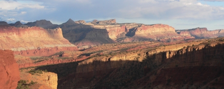
A diagonally ridged geological uplift surrounded by astounding natural formations, colors, canyons and mountains. There are neither capitol buildings nor reefs at the Park, just rock configurations that recall those more familiar concepts.
BEAUTY (10/10)
Are places more beautiful when one doesn’t know what to expect? Do low (or no) expectations inflate impressions? We had no idea what a monocline was, let alone looked like before we went to Capitol Reef NP. We now know it is one of the more striking geological features the U.S. has to offer.
The Waterpocket Fold, the “wrinkle” in the earth’s crust which the Park preserves, looks like a giant ocean wave frozen just as it breaks. This wave has been eroded by time, wind and water, exposing eons of colors and materials caught in the swell.
Land of the Sleeping Rainbow is the Navajo name for Capitol Reef. There is not one straight horizon line in the entire Site; everything is on a diagonal. Lucky for one of us (cough, Gab) that tends to take crooked pictures.
HISTORICAL INTEREST (4/10)
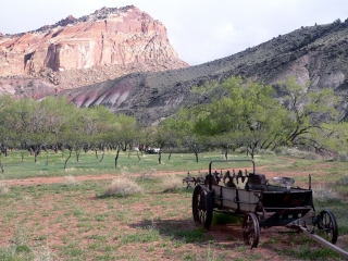
Native Americans known as the Fremont culture used the land around the Waterpocket Fold between the years of 800 and 1250. Mormon pioneers settled the area along the Fremont River in the 1800s. They founded the small town of Fruita, known for its orchards. While Mormons eventually moved on, the Park Service still maintains several groves of fruit trees.
Human history is dwarfed by the timeline evident in the cross section of rocks along the Waterpocket Fold. A helpful chart from the Visitor Center lists the landforms and colors of each type of rock and matches them to the corresponding age: Cretaceous, Jurassic, Triassic and Permian. They are all on display here.
 CROWDS (7/10) CROWDS (7/10)
Capitol Reef NP is a popular place. Families filled the VC and the campground. If we had any misgivings about camping in high altitude and chilly weather, the number of other tent sites and the rate at which they were filling told us to toughen up and grab a spot. We did and it was fine. We had several pleasant exchanges with other campers hiking in the late afternoon.
EASE OF USE/ACCESS (2/5)
The Park is located about an hour south of Interstate 70 and is not particularly far from Utah northern population centers. Most of the license plates in the campsite were from Utah. In addition, the restored buildings, gift store and orchard all emphasize the Mormon pioneer experience. It seems that the locals have kept this wonderful Park a secret.
CONCESSIONS/BOOKSTORE (5/5)
An awful lot of stuff is jammed into a small space here. Items for sale span the history of the Fremont River region. Pictograph magnets, wall hangings and pottery represent the people of the Fremont culture. Quilted potholders and cotton bonnets and aprons remind visitors of the Mormon settlers. Sesame Street interactive CD-ROMs hosted by the ever-adorable Elmo entice younger shoppers to explore the American west and learn more about the fascinating geology of the Park.
The Gifford House Store, located in the orchard near the campground, sells handcrafted Mormon pioneer goods. We got only as close as their website. The Gifford House Store keeps odd hours, opening at noon and only on selected days of the week.
 COSTS (4/5) COSTS (4/5)
Access to many of Capitol Reef’s prime attractions is absolutely free; our only National Park that can make this boast. Most of the trailheads and overlooks are located along Utah Route 24.
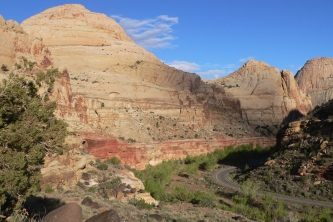
A five-mile long scenic drive follows south from the Visitor Center along the parks definitive geological landmark, the uplifted Waterpocket Fold. This drive costs $5, free with the National Parks Pass.
The scenic drive is stunning but is sort of a misnomer. Route 24, is where you’ll find the capitol domes, the rushing Fremont River, ancient petroglyphs and breathtaking panoramas. Route 24 may not be the Park’s geological definer but it is its aesthetic standout.
Fruita Campground sites cost $10. This 71 site developed campground is situated amidst lovely orchards and grass expanses so big that can easily allow intra family softball matches.
RANGER/GUIDE TO TOURIST RATIO (4/5)
There was only one Ranger at the VC but she, unlike her colleague at Navajo NM , managed the crowd effortlessly. She started the film, offered camping and hiking advice, distributed handouts and actually answered questions. Her laid back style and direct responses told us she was not new to Capitol Reef NP or its throngs of visitors. Man, she was good.
 TOURS/CLASSES (5/10) TOURS/CLASSES (5/10)
Geology is a difficult concept, at least for us. The age of the rocks and the amount of time it takes to carve a formation or deepen a canyon is hard to comprehend even when the end results are right in front of you. The short introductory slide show helped a little. Talking with the Ranger and perusing the Site’s handouts aided our understanding more.
There were no Ranger programs during our visit but the Ranger on duty was very helpful. She used a strip of foam to illustrate how the earth buckled and rolled and then eroded to give us the present landscape. Her simple explanation using a cheap visual aid was more effective than high-priced plasma TVs or touch screen computers that we have been left with at other sites.
FUN (8/10)
We knew we were in for something impressive when long ridges of multi-colored rocks appeared paralleling the road to the Park. They do look like a Reef! These waves of earth led the way into the Site, where they exploded into steep cliffs, white domes and deep gorges. The beauty of Capitol Reef NP took us completely by surprise.
We spent the afternoon taking the scenic drive, looking for the Pioneer Register on the walls of the Capitol Gorge, spotting petroglyphs along Route 24 and hiking the Hickman Bridge Trail for better views of the Hickman Bridge and Capitol Dome. The late afternoon sun altered the colors of the rock formations so much we were convinced that we had to find a good place to watch the sun set. We found it at, you guessed it, Sunset Point.
 WOULD WE RECOMMEND? (8/10) WOULD WE RECOMMEND? (8/10)
Capitol Reef NP is yet another affirmation of the trip. Here is a place of exquisite and unique beauty that we may have never seen had we not set out to find all of the National Parks. Did you know it existed? We didn’t.
Capitol Reef NP can easily be visited in a day. But because of its distance from any sizable cities, you may want to consider camping amid its apple, peach, cherry, pear and apricot trees. These delicious fruits are literally yours for the picking during your stay. There are certainly worse places to be.
TOTAL 57/80
|