Scotts Bluff National Monument
Gering, Neb.
Visited: July 9, 2004
NPS Site Visited: 64 of 353
NPS Website
 WHAT IS IT? WHAT IS IT?
Large rock formation near the North Platte River in the Nebraska panhandle. One of the few distinctive landmarks for early settlers and travelers on the Oregon, Mormon and California Trails and riders of the Pony Express.
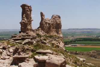
BEAUTY (6/10)
The stark range of high sand hills jutting above the Plains does impress. The towns of Gering and Scottsbluff spread out below the Bluff, as do Eagle Rock and Sentinel Rock. If you look closely, Chimney Rock is in the distance. Our rattlesnake anxieties kept our eyes focused downward, so we were also able to appreciate the numerous varieties of prairie grasses and flowers around the Bluff.
HISTORIC SIGNIFICANCE (6/10)
Driving from Omaha across the very flat state, we could appreciate the significance of the Bluff and empathize with the families and individuals in search of something in the west. With the exception of Chimney Rock, Scotts Bluff National Monument is one of the few things that break the monotony of the long, long drive. What took us six hours would have taken early settlers at least eleven days. In some areas, ruts from prairie schooners and wagons are still visible. These remnants of the Oregon Trail have lasted due to erosion and water running through and packing down the well-worn trails.
Scotts Bluff was named after Hiram Scott. The injured Scott was left behind by the rest of his Expedition Party and eventually perished on the bluff. We joked that even though Scott wasn’t liked enough to be saved by his group, someone liked him enough to name a hunk of rock in his honor. Go figure.
CROWDS (6/10)
A small but vocal group of senior citizens watched the Monument’s video with us. Their not-quite-whispered comments were more amusing than annoying. A few people wandered around the bookstore. Once we started walking to the top of the Monument, we passed one family and one individual. That’s it. Given that it was at least 90 degrees, we assume that most visitors opted to drive up to the top or take the free shuttle.
 EASE OF USE/ACCESS (3/5) EASE OF USE/ACCESS (3/5)
The Scotts Bluff NM can be seen for miles. The Visitor Center is not far from the town center of Gering, Nebraska off State Road 92. The Center itself is an older building, one story, but a little cramped inside. Bathrooms are in a separate, more accessible building. Water fountains are placed in several locations since the weather is often sunny, dry and hot.
Scotts Bluff NM now offers a free shuttle van up and down the Bluff for visitors who would like to see the top but would rather not walk or drive themselves. We took advantage of the shuttle for the trek back down the bluff. Since there were few visitors to the site, we were able to call from our cell phone and the van was there in minutes. On busier days, the shuttle will run 2-3 times an hour.
CONCESSIONS/BOOKSTORE (2/5)
Not great. There was not a wide selection of books. None of the souvenirs appealed to us. The Tour Guide that we bought was not at all what we thought it would be.
COSTS (2/5)
Entrance to the Monument is free with the National Parks Pass, five dollars per vehicle good for seven days without it. Five dollars seems steep given that there are no Ranger-led tours or modern facilities at the site.
RANGER/GUIDE TO TOURIST RATIO (2/5)
Scotts Bluff NM is clearly short staffed. We were reminded of this every time we asked for information and volunteers scrambled to find the one Ranger that was on duty during our visit.
TOURS/CLASSES (4/10)
We visited Scotts Bluff NM with a Gering native. He confirmed that the displays, photographs, even the dioramas had not changed since the last time he visited the site – over twenty years ago. The exhibits definitely show their age.
We purchased a tour guide for 50 cents without reviewing its contents. Bad move. What we had thought would be a step by step explanation of the hike to the top of the Bluff turned out to be just a listing of the short walks one can take at the top of the Bluff. The guide offered no information that was not present on signs at the beginning of each walk.
When we asked if there were any interpretive talks offered, staff at the desk seemed flustered, as if they didn’t know what exactly we were asking. They called upon a Ranger who explained that no talks were offered today since the other Ranger was out to lunch and they were short staffed. She suggested that we stop by the next morning when she would give a short talk near two reconstructed wagons and explain their contents.
After watching the film and walking to the top of the Bluff to examine the scenery below, one question was nagging us so much that we had to return to the Visitor Center and search for an answer: why didn’t followers of the Oregon Trail just cross the Platte River and utilize the much easier North bank of the river like the Mormons did? The Platte is not overly wide. It was no deeper then than it is now. To us, it did not seem impossible to cross and the end result would have been a much less treacherous pass across the sand hills.
We did find a Ranger and she told us that although the Platte is not wide, it has no solid bottom. In other words, stepping into the silty water would feel like stepping into quicksand – something one wouldn’t want to do with their livestock and wagon in tow. In fact, the shallower the water, the more difficult it may have been to cross. The Mormon’s starting point in Nauvoo, Illinois placed them on the North side of the Platte and offered them the (relatively) easier trail.
 FUN (5/10) FUN (5/10)
We enjoyed the mildly strenuous walk up the Bluff on a beautiful day. While we were disappointed with the contents of the Visitor Center, we were moved by the natural wonder of the Bluff and the portions of the Oregon Trail that still remain.
WOULD WE RECOMMEND? (5/10)
Seeing the ruts, experiencing the drive and the relief of finally coming upon a recognizable land marker connected us with generations of American travelers. If you are making the drive across country, it makes sense to stop here.
TOTAL 41/80
|